Kingston's built environment sits on a foundation shaped by centuries of limestone construction and glacial sediment deposition. The city's historic downtown, with its 19th-century masonry landmarks from the era when Kingston served as the first capital of the Province of Canada, rests atop the Ordovician limestone of the Black River Group. This same formation creates both opportunities and challenges for modern development. Our seismic refraction surveys map the top-of-bedrock profile beneath urban fill and glacial till, while seismic tomography provides a velocity cross-section that reveals lateral changes in rock quality that boreholes alone can miss. In the Cataraqui River corridor, where former industrial lands are being redeveloped, understanding the precise depth to competent limestone determines whether shallow foundations are viable or whether deeper support systems become necessary. The technique sends acoustic waves through the subsurface and records their travel times along multiple receiver arrays, then processes the data through iterative inversion algorithms to generate a two-dimensional velocity model of the ground. For projects near the Rideau Canal or in the Portsmouth Harbour area, where water saturation and fractured rock interfaces complicate drilling interpretation, seismic tomography adds a layer of imaging resolution that transforms how geotechnical consultants approach foundation design in Kingston's complex geological setting.
A single seismic tomography line can replace four to six exploratory boreholes when mapping bedrock depth and lateral velocity variations across a Kingston building site.
Our approach and scope
Site-specific factors
Kingston's population of approximately 136,000 occupies a region where the Western Quebec Seismic Zone generates roughly 150 detectable earthquakes each year, with the most recent significant event being the 2010 Val-des-Bois earthquake that registered magnitude 5.0 and was felt strongly across the city. The combination of seismic hazard and soluble limestone bedrock creates a dual risk scenario that conventional site investigation methods struggle to characterize. Solution cavities and enlarged fractures within the Black River and Gull River formations can collapse under foundation loads, while the impedance contrast between intact rock and void-filled zones amplifies ground motion during seismic events. Seismic tomography identifies these features because voids, clay-filled fissures, and fractured rock produce distinctive low-velocity anomalies on the tomogram. A site classified as Site Class C by sparse borehole data might actually contain enough weathered or void-bearing rock to behave as Site Class D or E under dynamic loading, triggering a more conservative structural design requirement. The cost of missing this condition during investigation multiplies significantly if discovered during excavation, when foundation redesign and construction delays compound. For hospital expansions, municipal infrastructure, and multi-storey developments in Kingston's downtown core, the imaging capability of cross-hole or surface-based seismic tomography provides the geological certainty that the NBCC seismic provisions demand.
Regulatory framework
NBCC 2020 – National Building Code of Canada, Division B, Part 4: Structural Design (seismic site classification), CSA A23.3:19 – Design of Concrete Structures, Annex D for foundation design parameters, ASTM D5777-18 – Standard Guide for Using the Seismic Refraction Method for Subsurface Investigation, ASTM D7128-18 – Standard Guide for Using the Seismic Reflection Method for Shallow Subsurface Investigation, OPSS.MUNI 206 – Ontario Provincial Standard Specification for geotechnical investigation and reporting
Related services
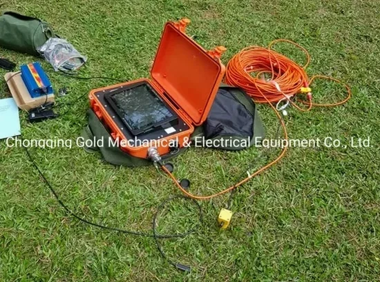
Seismic Refraction Tomography
A 2D velocity imaging method that maps the boundary between glacial overburden and the underlying Paleozoic limestone. We deploy 24- or 48-channel arrays with 3-5 metre geophone spacing to achieve resolution suitable for foundation design, utility corridor planning, and bedrock rippability assessment. The processed tomogram shows P-wave velocity contours that geotechnical engineers use to delineate competent rock, weathered zones, and potential karst features beneath Kingston's variable glacial till cover.
Seismic Reflection Profiling
A deeper imaging technique that resolves stratigraphic boundaries and fracture zones within the limestone sequence at depths beyond the reach of refraction methods. Reflection surveys on Kingston's former industrial waterfronts and along major transportation corridors map sub-horizontal bedding planes and solution-enhanced fractures that influence groundwater flow and slope stability. The data integrates with borehole logs to extend geological interpretation laterally across sites where access for drilling is limited by existing structures or environmental constraints.
Typical parameters
Common questions
What is the typical cost range for a seismic tomography survey at a building site in Kingston?
For a standard commercial or institutional building site in Kingston, a seismic refraction tomography survey typically falls between CA$3,810 and CA$8,180, depending on the survey line length, number of geophone channels deployed, and the target depth of investigation. A smaller residential or light commercial survey using a 24-channel array with a single spread may sit at the lower end, while a multi-line survey requiring 48-channel acquisition and reflection processing for deeper targets reaches the upper range. Terrain accessibility also affects pricing: sites with dense vegetation, steep slopes along the Cataraqui River valley, or urban locations requiring traffic control add logistical costs that are reflected in the final proposal.
How does seismic tomography complement conventional borehole investigation in the Kingston area?
Boreholes provide precise point measurements of stratigraphy and strength, but Kingston's limestone bedrock contains solution features and fracture zones that can change significantly over distances of just a few metres. Seismic tomography fills the gap between boreholes by producing a continuous velocity cross-section that reveals lateral changes in rock quality, weathered zones, and potential cavities. When borehole data is used to calibrate the velocity-to-material correlation, the tomogram becomes a reliable predictor of subsurface conditions across the entire survey line, reducing the number of boreholes needed and lowering the risk of encountering unexpected conditions during excavation.
What site classification does a seismic survey provide under the Ontario Building Code?
Under the Ontario Building Code, which references NBCC 2020 for seismic provisions, seismic tomography provides the shear wave velocity (Vs) measurements needed to assign a Site Class from A (hard rock) to E (soft soil). The survey measures Vs30, the average shear wave velocity in the upper 30 metres, which is the primary parameter for site classification. In Kingston, where limestone bedrock underlies much of the city, many sites classify as Site Class C or D depending on the thickness and stiffness of the overburden. The tomographic data also supports site-specific response analysis for critical facilities, where the code permits a more refined classification than the default table values.
Can seismic surveys detect underground voids or caves in the Kingston limestone?
Yes, both refraction and reflection tomography can identify voids and solution cavities in the limestone bedrock when the cavity dimensions are large enough relative to the survey resolution. An air-filled or clay-filled cavity produces a pronounced low-velocity anomaly because seismic waves travel more slowly through void space or soft infill than through competent limestone. The detection threshold depends on cavity size, depth, and the geophone spacing used; for typical Kingston site investigation arrays with 3-5 metre geophone spacing, cavities greater than approximately 1.5 metres in diameter at depths shallower than 20 metres are reliably identifiable. For smaller features or deeper targets, cross-hole tomography between boreholes provides higher resolution.